Space Newsspace history and artifacts articlesMessagesspace history discussion forumsSightingsworldwide astronaut appearancesResourcesselected space history documents
advertisements
Photo Gallery:Sharpest ever views of Apollo moon landing sites
September 7, 2011
— NASA's Lunar Reconnaissance Orbiter (LRO) captured the sharpest images ever taken from space of the Apollo 12, 14 and 17 landing sites. Images show the twists and turns of the paths left by astronauts as they explored the lunar surface. [Related article]
"We can retrace the astronauts' steps with greater clarity to see where they took lunar samples," Noah Petro, a lunar geologist at NASA's Goddard Space Flight Center in Greenbelt, Md., said.
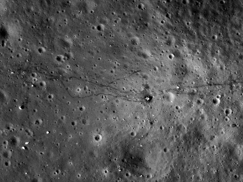
All three images show the distinct trails made in the moon's thin soil when the astronauts exited the lunar modules and explored on foot. In the Apollo 17 image, the foot trails, including the last path made on the moon by humans, are easily distinguished from the dual tracks left by the lunar rover, which remains parked east of the lander.
Credit: NASA Goddard Space Flight Center / ASU
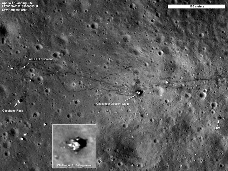
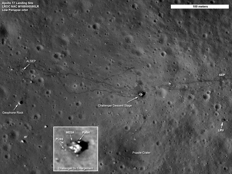
Apollo 17 landing site
The twists and turns of the last tracks left by humans on the moon crisscross the surface in this LRO image of the Apollo 17 site. In the thin lunar soil, the trails made by astronauts on foot can be easily distinguished from the dual tracks left by the lunar roving vehicle, or LRV. Also seen in this image are the descent stage of the Challenger lunar module and the LRV, parked to the east.
The LRV gave the Apollo 17 astronauts, Eugene Cernan and Harrison Schmitt, considerable mobility. As in previous Apollo missions, the astronauts set up the lunar monitoring equipment known as the Apollo Lunar Surface Experiments Package (ALSEP), the details of which varied from mission to mission. To the west of the landing site, the cross-shaped path that the astronauts made as they set up the geophones to monitor seismic activity can be seen.
To the east, more rover tracks can be seen. Cernan made these when he laid out the 35-meter antennas for the Surface Electrical Properties, or SEP, experiment. SEP, a separate investigation from ALSEP, characterized the electrical properties of the lunar soil.
Below the SEP experiment is where the astronauts parked the rover, in a prime spot to shoot video of the liftoff of the Challenger module.
Apollo 14 landing site
The paths left by astronauts Alan Shepard and Edgar Mitchell on both Apollo 14 moon walks are visible in this LRO image. (At the end of the second moon walk, Shepard famously hit two golf balls.) The descent stage of the lunar module Antares is also visible.
Apollo 14 landed near Fra Mauro crater in February 1971. On the first moon walk, the astronauts set up the lunar monitoring equipment known as the Apollo Lunar Surface Experiments Package (ALSEP) to the west of the landing site and collected just over 42 kilograms (about 92 pounds) of lunar samples. Luckily for them, they had a rickshaw-style cart called the modular equipment transporter, or MET, that they could use to carry equipment and samples.
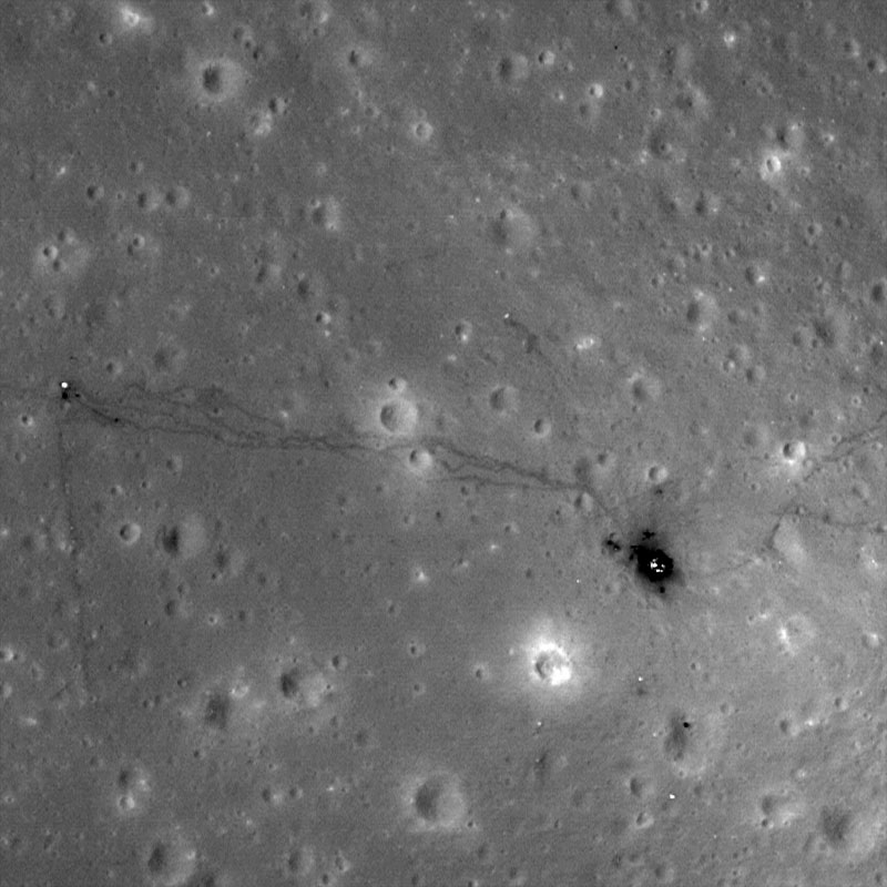
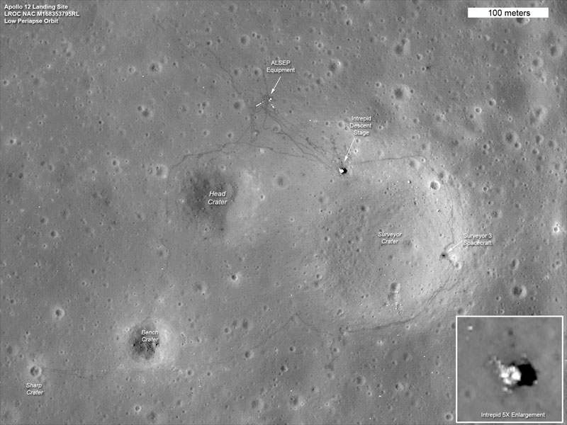
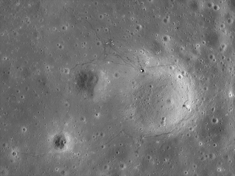
Apollo 12 landing site
The tracks made in 1969 by astronauts Pete Conrad and Alan Bean, the third and fourth humans to walk on the moon, can be seen in this LRO image of the Apollo 12 site. The location of the descent stage for Apollo 12's lunar module, Intrepid, also can be seen.
Conrad and Bean performed two moon walks on this flat lava plain in the Oceanus Procellarum region of the moon. In the first walk, they collected samples and chose the location for the lunar monitoring equipment known as the Apollo Lunar Surface Experiments Package (ALSEP). The ALSEP sent scientific data about the moon's interior and surface environment back to Earth for more than seven years.
One of the details visible in this image is a bright L-shape that marks the locations of cables running from ALSEP's central station to two of its instruments. These instruments are probably (left) the Suprathermal Ion Detector Experiment, or SIDE, which studied positively charged particles near the moon's surface, and (right) the Lunar Surface Magnetometer, or LSM, which looked for variations in the moon's magnetic field over time; these two instruments had the longest cables running from the central station. Though the cables are much too small to be seen directly, they show up because the material they are made from reflects light very well.
In the second moon walk, Conrad and Bean set out from the descent stage and looped around Head crater, visiting Bench crater and Sharp crater, then headed east and north to the landing site of Surveyor 3. There, the astronauts collected some hardware from the unmanned Surveyor spacecraft, which had landed two years earlier.
The two astronauts covered this entire area on foot, carrying all of their tools and equipment and more than 32 kilograms (roughly 60 pounds) of lunar samples.