|
|

|
|
Author
|
Topic: Maxar satellites non-Earth imaging capability
|
Robert Pearlman
Editor Posts: 49612
From: Houston, TX
Registered: Nov 1999
|
 posted 12-06-2022 09:40 AM
   
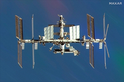
Maxar Technologies today (Dec. 6) announced that the National Oceanic and Atmospheric Administration (NOAA) has modified Maxar's remote sensing license to enable the non-Earth imaging (NEI) capability for its current constellation on orbit as well as its next-generation WorldView Legion satellites. Through this new license authority, Maxar can collect and distribute images of space objects across the Low Earth Orbit (LEO) — the area ranging from 200 kilometers up to 1,000 kilometers in altitude — to both government and commercial customers. Maxar's constellation is capable of imaging objects at less than 6 inch resolution at these altitudes, and it can also support tracking of objects across a much wider volume of space. As an example, Maxar imaged the International Space Station: |
SkyMan1958
Member Posts: 1254
From: CA.
Registered: Jan 2011
|
 posted 12-06-2022 10:32 AM
   
While I am sure the DoD has higher resolution on orbit imagery of manmade objects, I am also sure that it was the DoD that had a hand in this. Given the on orbit behavior of the last few years of "near-peer" competitors, it makes perfect sense for the USA (oh, excuse me, cough, cough, Maxar) to keep high resolution tracking of satellites of interest during periods of time when Earth observation is not necessary. Basic redundancy... | |
Contact Us | The Source for Space History & Artifacts
Copyright 2022 collectSPACE.com All rights reserved.

Ultimate Bulletin Board 5.47a
|
|

|
 advertisement advertisement

|


