The first to map active lava flows from space.
The first to measure a facility's methane leak from space.
The first to track re-growth in a partially logged Amazon forest from space.
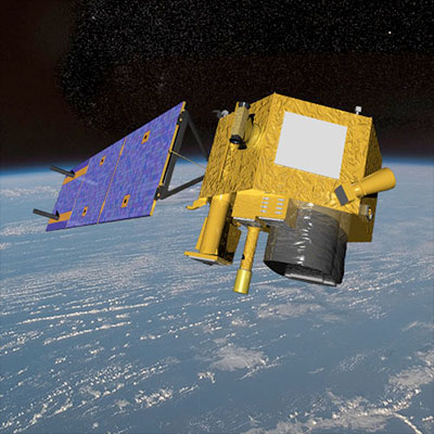
After 17 years in orbit, one of NASA's pathfinder Earth satellites for testing new satellite technologies and concepts comes to an end on March 30, 2017. The Earth Observing-1 (EO-1) satellite will be powered off on that date but will not enter Earth's atmosphere until 2056.

Launched on Nov. 21, 2000, EO-1 was designed as a technology validation mission focused on testing cutting-edge satellite and instrument technologies that could be incorporated into future missions. Commissioned as part of NASA's New Millennium Program, the satellite was part of a series of missions that were developed at a cheaper price tag to test new technologies and concepts that had never been flown before.
"EO-1 has changed the way spectral Earth measurements are being made and used by the science community," said Betsy Middleton, EO-1's Project Scientist at NASA's Goddard Space Flight Center in Greenbelt, Maryland.
EO-1 was launched with 13 new technologies, including three new instruments. EO-1's most important technology goal was to validate the Advanced Land Imager (ALI) for future Earth-observing satellites. The ALI provided a variety of Earth data including observations of forest cover, crops, coastal waters and aerosols. The ALI's instrument design and onboard technology directly shaped the design of the Operational Land Imager (OLI) on Landsat 8, currently in orbit.
EO-1's other key instrument is a hyperspectral instrument called Hyperion that allows scientists to see chemical constituents of Earth's surface in fine detail with hundreds of wavelengths. These data allow scientists to identify specific minerals, track vegetation type and vigor of forests and monitor volcanic activity. The knowledge acquired and technology developed from Hyperion is being incorporated into a NASA concept for a potential future hyperspectral satellite, the Hyperspectral Infrared Imager, that will study the world's ecosystems, such as identifying different types of plants and assessing wildfires and droughts.

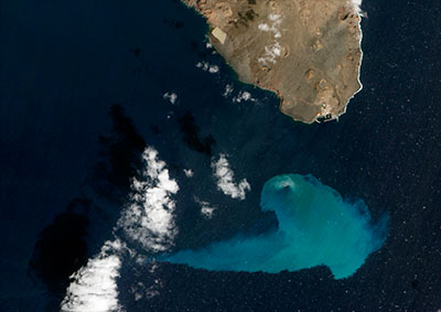
Above: This image taken by EO-1's Advanced Land Imager on Feb. 10, 2012, shows an underwater volcanic eruption off El Hierro Island in the Atlantic Ocean.
With both of these instruments, the EO-1 team was able to acquire images with high spatial resolution of events and natural disasters around the world for anyone who requested it. The EO-1 team could point the instruments at any specific location and gather images every two to five days of a particular spot, which was very useful for scientists as well as disaster relief managers trying to stay informed of rapidly changing events. (Landsat typically looks at the same area once every 16 days.) EO-1 captured scenes such as the ash after the World Trade Center attacks, the flooding in New Orleans after Hurricane Katrina, volcanic eruptions and a large methane leak in southern California.
EO-1 also served as a valuable pathfinder for a variety of space technologies. Technologists installed and tested autonomy software on EO-1 that allowed the satellite to make its own decisions based on the content of the data it collected. For instance, if a scientist instructed EO-1 to take a picture of an area where a volcano was currently erupting, the software could decide to automatically take a follow-up image the next time it passed over the location.
The mission also validated software that allowed "formation flying" that kept EO-1 orbiting Earth exactly one minute behind the Landsat-7 satellite, already in orbit. The original purpose was to validate the new ALI technologies for use in Landsat 8, which was accomplished.

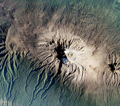
Above: This image taken by EO-1's Advanced Land Imager (ALI) on Jan. 20, 2017, shows snowcap of the volcanic Mount Kilimanjaro.
EO-1 was originally only supposed to last one year, but after that initial mission, the satellite had no major issues or breakdowns. On a shoestring budget contributed by NASA, the U.S. Geological Survey, the National Oceanic and Atmospheric Administration, National Reconnaissance Office and Naval Research Laboratory, the satellite continued to operate for sixteen more years, resulting in more than 1,500 papers published on EO-1 research.
On March 30, 2017, the satellite will be decommissioned, drained of its energy and become inert. Without enough fuel to keep EO-1 in its current orbit, the mission team will shut down the satellite and wait for it to return to Earth. When EO-1 does reenter the earth's atmosphere in about 39 years, it is estimated that all the components will burn up in the atmosphere.
"We'll probably just see EO-1 as a streak in the sky as it disintegrates," said Middleton.


