This image, taken by the Advanced Moon Micro-Imager Experiment (AMIE) on board ESA's
SMART-1 spacecraft, shows the Hadley Rille on the south-east edge of Mare Imbrium on the Moon.
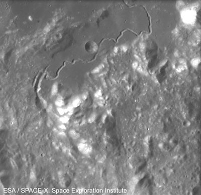
AMIE obtained this image from an altitude of about 2000 kilometers. It covers an area of about 100 kilometers and shows the region around Hadley Rille centered at approximately 25 degrees North and 3 degrees East.
The sinuous rille follows a course generally to the north-east toward the peak of Mount Hadley, after which it is named (bright feature, top right). To the east of this rille, south-west of Mount Hadley, is Mount Hadley Delta, one of the largest Appenine mountains.
The Appenine mountains mark the edge of the impact basin holding Mare Imbrium, rising between 1800 and 4500 meters above the mare. They are the bright bumps in the lower half of the image.
The valley between these two peaks is fairly well known because NASA astronauts David R. Scott and James B. Irwin landed there during the Apollo 15 mission in 1971. The landing site is near the upper right part of the rille (26.1° North and 3.9° East) on a dark mare plain called Palus Putredinis (Marsh of Decay).
The rille begins at the curved gash on the left side of this image, and is seen clearest in the rectangular, mare-floored valley in the center of the image. It is over 120 kilometers long, and up to 1500 meters across and over 300 meters deep in places.
The rille formed nearly 3300 million years ago. In contrast, lava channels on Hawaii are usually under 10 kilometers long and are only 50-100 meters wide. The Hadley C crater next to the rille is about 5 kilometers in diameter.
Sinuous rilles are probably the most recognizable of small volcanic features on the Moon. Many partially resemble river valleys on Earth. However, the lunar rilles usually flow away from small pit structures.
The rilles mark lava channels or collapsed lava tubes that formed during mare volcanism. Indeed, the lunar samples indicate that the Moon has always been dry, thus confirming the volcanic origin of the rilles.
Still, in some cases, the lunar flows may have melted their way down into older rocks, much like rivers cut into their flood plains on Earth. Similar lava channels and tubes are found in Hawaii, but these are all much, much smaller than those found on the Moon, indication that the very low lunar gravity has a strong influence on morphological processes.


 posted 07-27-2005 03:45 PM


