|
Author
|
Topic: Apollo 11 photo: map position and orbit
|
rgarner
Member Posts: 1193
From: Shepperton, United Kingdom
Registered: Mar 2012
|
 posted 02-14-2019 07:12 AM
   
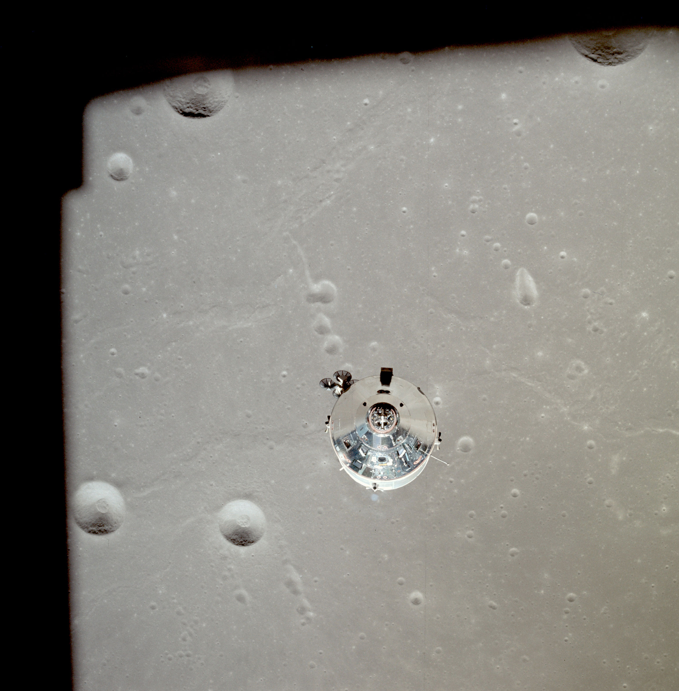
Okay, so I've set out on a bit of a weird endeavour. The below Apollo 11 photograph (AS11-37-5445) was taken over Craters Taruntius K, Taruntius P, and Dorsum Cayeux (in Mare Fecunditatis) with craters Anvil and Taruntius H being partially visible.Essentially what I am trying to do is: - Find the position of this site on a lunar map (high def image, ideally 300dpi) so I can pinpoint where the photo was taken.
- Find the direction of the orbit in which the Apollo CM was travelling at the time.
- Find out exactly which orbit this was when the photo was taken (I'm not sure how many times the CM orbited above while Armstrong and Aldrin were below).
I would appreciate the help! |
drifting to the right
Member Posts: 114
From: SW La.
Registered: Aug 2006
|
posted 02-14-2019 08:35 AM
Position is between 49E and 52E on Descent Chart. Flight path is from bottom of photo towards top (E to W). Don't know orbit number. [Original of this segment of flown Apollo 11 Descent Chart is in my collection]. |
rgarner
Member Posts: 1193
From: Shepperton, United Kingdom
Registered: Mar 2012
|
posted 02-14-2019 09:07 AM
Thank you, that answers part of my question! I don't suppose you know where I can find a copy of a complete Apollo 11 descent chart? |
olympusmonsuk
Member Posts: 16
From: Billericay, Essex, England
Registered: May 2011
|
posted 02-14-2019 09:10 AM
AS11-37-5445 was taken by Neil Armstrong on revolution 13 at approximately 100:33:20. This was roughly 6 minutes prior to the CSM performing the RCS separation manuever. The CSM attitude was nose down pointing at the centre of the Moon.I have a location map which I can send if you could provide your email address. Hope this helps. Intrigued what you need this info for? |
rgarner
Member Posts: 1193
From: Shepperton, United Kingdom
Registered: Mar 2012
|
posted 02-14-2019 09:15 AM
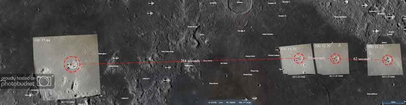
That is perfect, thank you! My email address is moonandmars@hotmail.co.ukI can't reveal the exact reason why I need it (yet), but essentially I'm creating a type of storyboard for this part of the mission and I am trying to gather as much relevant data as I can. This photo is one of 4 taken in sequence, so I'm trying to map each one but felt it would be easier to start with one. The sequence is: AS11-37-5443
AS11-37-5444
AS11-37-5445
AS11-37-5446 |
olympusmonsuk
Member Posts: 16
From: Billericay, Essex, England
Registered: May 2011
|
posted 02-14-2019 09:17 AM
Give me a few minutes and I will provide maps for all of these. |
rgarner
Member Posts: 1193
From: Shepperton, United Kingdom
Registered: Mar 2012
|
posted 02-14-2019 09:20 AM
Thank you very much! If you want to be credited let me know your full name and I'll make sure it happens. |
rgarner
Member Posts: 1193
From: Shepperton, United Kingdom
Registered: Mar 2012
|
posted 02-14-2019 02:22 PM
quote:
Originally posted by drifting to the right:
Position is between 49E and 52E on Descent Chart. Flight path is from bottom of photo towards top (E to W). Don't know orbit number.
Are you referring to the lunar module here? The path of the CSM seems to be different from the position you're referencing. I've superimposed the photographs directly onto the chart as part of my efforts and I "think" it takes the CSM on a different path?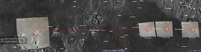 |
drifting to the right
Member Posts: 114
From: SW La.
Registered: Aug 2006
|
posted 02-14-2019 02:53 PM
Yes, reference is from LM Descent Chart which shows position over this site at 3.5-2.5 min before PDI, undoubtedly on a later orbit. |