Space News space history and artifacts articles Messages space history discussion forums Sightings worldwide astronaut appearances Resources selected space history documents |
If you have previously registered, but forgotten your password, click here.
Google Maps with Street View lets you explore Kennedy's facilities, roads and structures through 360-degree street-level imagery that includes the Apollo/Saturn V Center, Space Shuttle Main Engine shop, Orbiter Processing Facility-3, the Launch Control Center, the Space Station Processing Facility and the center's iconic Vehicle Assembly Building. Users may go directly to Google Maps, search for "NASA Shuttle Landing Facility," and drag the orange "pegman" icon on the left-hand side to an area outlined in blue. From there, users can navigate around the area by moving up and down pathways and looking around in 360 degrees. The entire collection of images also is available in the Google Street View gallery. 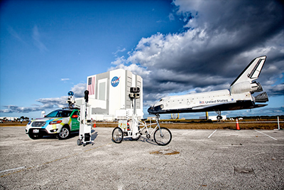 The Street View feature in Google Maps enables users to see Kennedy as it transitions to the multipurpose launch complex of the future, revamping existing infrastructure and facilities to provide the flexibility to host a variety of commercial and government spacecraft, rockets and other craft. | ||||||||
| rwhite502 | Neat! Firing Room 1 appears to be "locked."  Sign on the door of FR2 - "Abandon in Place" - how sad. | |||||||
| LM1 | Looks like Endeavour and Atlantis are both in the VAB at the same time. When were these images taken? | |||||||
| rjscott | quote:The images are dated January 2012. | |||||||
| ilbasso | These are much more exciting that the Google Street View of my house. The Street View camera managed to get a back-end shot of my wife bending over while picking up sticks in our yard! | |||||||